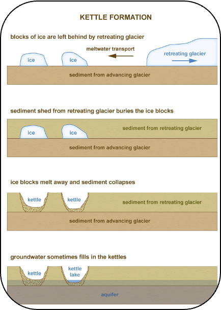
The deeper of the Wellfleet kettle ponds (Duck, Dyer, Great, Gull, and Long) were formed between 10,000 to 13,000 years ago. The meltwater from the retreating glacier deposited outwash sand and gravel over the top of gigantic blocks of ice that broke off the glacier. As these huge blocks of ice melted, they left behind “kettle” holes.
The shallower of the Wellfleet ponds formed later in geological time when rising sea levels from melting glaciers pushed the freshwater lens upward until it rose above the dry kettle hole basins to fill them.
The freshwater lens is the layer of fresh ground-water that floats above the salty groundwater that underlies the Outer Cape land mass.
It is likely that the ponds were initially irregular in shape. Exposure to centuries of circular shoreline currents made the rounded contours we see today.
Did You Know?
What goes in our ponds stays in our ponds!
Kettle ponds are not stream-fed. They lack surface water inflows and depend on replenishment by groundwater and precipitation.
A key takeaway from that is: whatever we put in the pond stays there a long time – be it sunscreen, pee, fertilizer runoff from gardens, lawns, roadways and parking lots, or wastewater from cesspools and septic systems. These and other contaminants can accumulate and impact the health of our ponds over time.
Research completed at Gull Pond has shown that nitrogen and phosphorus remain in the sediment for up to 15 years!
Where Does the Water Come From That Replenishes Our Ponds Today?
Wellfleet pond water levels today are a reflection of local groundwater levels. Annual precipitation also contributes. All our pond bottoms are below sea level.
Wellfleet is part of the Chequessett groundwater lens, which ranges from six to nine feet above sea level. This groundwater continuously flows by gravity towards the ocean or bay. Ponds located along this groundwater flow path receive water along their upward sides (where the groundwater is flowing from) and discharge water back into the groundwater lens on their downward sides (where the groundwater is flowing to), as shown in the graphic at right.
Freshwater and saltwater flow lenses of the Lower Cape Cod aquifer system (modified from Strahler, 1972).
Although Wellfleet’s ponds were formed via the same geologic processes, every pond is different in terms of its specific geological structure, surface area, depth and volume.
Ecological features, along with the species of plants and animals that make the pond their home, also vary widely from pond to pond.
Surrounding development patterns, ease of access, and levels of human use also vary widely and can greatly influence the character and quality of each of the ponds.
“When you’ve seen one Wellfleet pond, you’ve seen one Wellfleet pond”